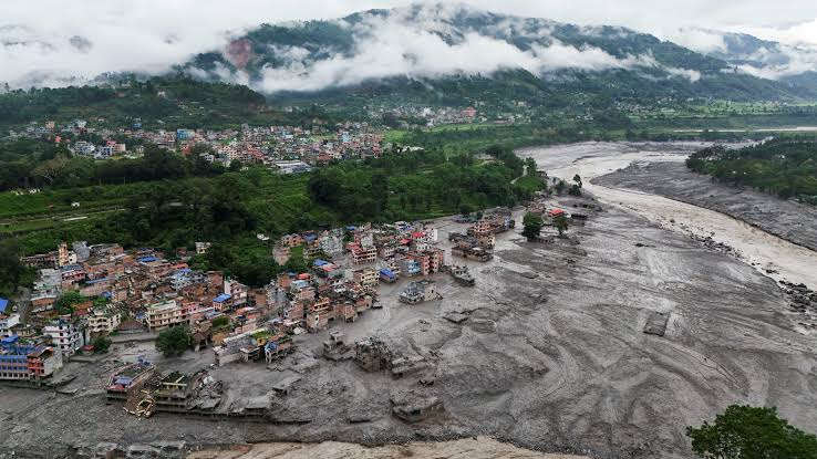
Glaciers across the Tibetan Plateau are likely to become increasingly unstable, raising the risk of more collapses and cascading disasters similar to last week’s deadly flash floods along the Nepal-Tibet border, a senior Chinese climate official has warned.
Gao Rong, deputy director of China’s National Climate Centre, said the Tibetan Plateau had lost around 24 per cent of its glacier area over the past six decades, with about 7,000 small glaciers disappearing completely.
“Looking ahead, the structural stability of glaciers across the Tibetan Plateau will decline further,” Gao said, according to the Hong Kong-based South China Morning Post. She warned that glacial disasters could become more frequent and potentially more destructive as their effects cascade downstream.
The warning comes after an ice-rock avalanche near the Nepal-Tibet border on August 26 triggered flash floods that devastated settlements in northern and central Nepal.
According to figures released by Chinese authorities on Wednesday, 21 people were killed and 541 remained missing following the disaster at Gyirong Port on the Tibet side of the border.
The missing included 261 foreigners, among them 49 Indians and nationals of 22 other countries, China’s state-run Xinhua news agency reported on August 30, citing an official briefing in Tibet.
In Nepal, the death toll from the floods rose to 1,252 on Thursday as rescue teams recovered more bodies from affected areas.
Glacier collapse turned into massive mudslide
A report by the Institute of Tibetan Plateau Research under the Chinese Academy of Sciences found that the mudslide generated by the glacier collapse travelled around 22 km through the valley and reached Gyirong Port in just seven minutes.
Researchers analysing satellite and field data from Gyirong county found that the collapsing ice and rock swept through the valley, scouring the riverbed and carrying debris from the banks. The material mixed with water as it moved downhill, transforming a high-altitude collapse into a much larger and more destructive mudslide.
The findings suggest that conventional assessments of glacial hazards, which focus largely on the initial volume of material that collapses, may not adequately capture the eventual scale of a disaster.
Researchers said risk assessments in high-mountain cryospheric regions should also account for the potential for a landslide to accumulate additional material as it travels downstream, as well as the population and infrastructure exposed to the resulting hazard chain.
Need for better early-warning systems
The disaster has also highlighted gaps in existing monitoring and forecasting systems.
An article published in Nature on Wednesday said the event was particularly difficult to predict because it resulted from the sudden failure of a high-altitude glacier-rock system rather than more commonly monitored warning signs such as extreme rainfall or the rapid expansion of glacial lakes.
Manoochehr Shirzaei, a geophysicist at Virginia Tech, said conventional monitoring systems were inadequate for detecting such events and called for more integrated approaches.
The Nature report highlighted the need for a regional satellite-based system capable of routinely detecting accelerating deformation in glaciers and unstable rock slopes and linking those observations with downstream flood and avalanche modelling.
The latest findings underscore the growing challenge posed by climate-driven changes in the Himalayan and Tibetan cryosphere, where the destabilisation of glaciers and mountain slopes can set off interconnected chains of hazards far beyond the site of the initial collapse.